
Cycling route Valley of the Ruiten Aa and Peat Colonies
Cycling through an intimate Groningen landscape of meandering stream valleys, ancient woodlands and heath fringes, interspersed with wide canals and straight peat-colony ribbon settlements.
The Landscape
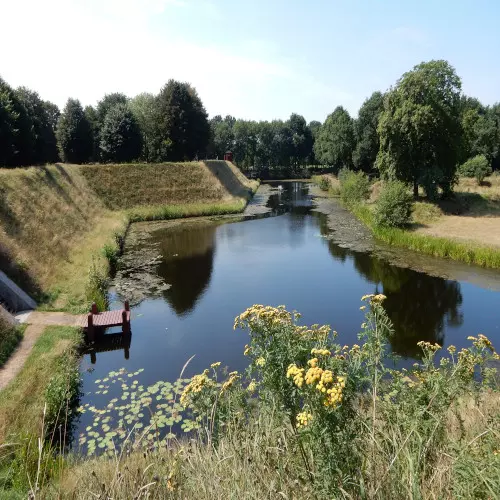
The Ruiten Aa is a picturesque stream that has shaped the green landscape of Westerwolde for centuries, with its meanders, hedgerows and quiet grasslands. You start at Klooster Ter Apel, tucked away beside the Ter Apelerbossen, and then follow a varied scenery of heathland, woodland edges and small villages full of character. A highlight awaits at Vesting Bourtange, a beautifully restored fortified town where history and landscape come together.
In the Peat Colonies, the rhythm changes immediately, with long lines of canals, ditches and linear villages that neatly structure the flat fields. This is a landscape shaped by peat extraction and water management, where peat barges once made their way past small bridges, locks and old farmhouses. You cycle beneath a wide sky along fields of sugar beet, potatoes, grain and onions calm and open, yet full of stories.
What You’ll Discover Along the Way
In the Ter Apelerbossen, you cycle among ancient oaks and beeches, with winding paths and quiet woodland sections that give the landscape a sheltered feel. Along the edges, small heathland patches and sandy soils open up into light-filled views, allowing woodland and openness to alternate naturally.
Around Ter Apel, you cycle through a cultural-historical landscape with Klooster Ter Apel as a recognisable landmark in the region. A little further on, the route takes you to Vesting Bourtange, where fortress design and border history become tangible in the ramparts, moats and street pattern.
You notice how wet hollows, marshy edges and hidden pools make the landscape rich in birdlife and full of variety, right at the transition from higher sandy soils to peatland. This region was once home to the vast Bourtangerveen, whose reclamation and water management are still visible today in the soil, ditches and sense of space.
The Ruiten Aa forms the green backbone of the route, with meanders that give the stream valley a gentle, natural rhythm. Near Ter Apel, the Bosbeek joins as an extension of the Ruiten Aa, where water and woodland come together in a striking way.
Ride along with us on this virtual bike tour
Virtually cycling through the Ruiten Aa Valley and the Peat Colonies lets you experience from home the contrast between the intimate stream valley of Westerwolde and the wide-open peat colonies. In the video, you ride along the meanders of the Ruiten Aa, past woodland edges near Ter Apel and along quiet views across grassland.
After that, long canals, ditches and ribbon villages follow, with small bridges, locks and old farmhouses as recognisable landmarks along the route. Ideal for the hometrainer or for exploring the route in advance, with a steady pace and plenty of variety.
Want to learn more about virtual cycling? THIS IS HOW VIRTUAL CYCLING WORKS

Route map and cycling junctions
Start and finish at cycling junction 24 on the Boslaan in Ter Apel. Because this is a circular route, you can also start at one of the other cycling junctions along the route.
Distance: 56 km
Estimated riding time: 3 hours 45 minutes
Elevation gain: 158 m
Paved roads: 88%
Unpaved / semi-paved: 12%
Ideal for: e-bikes and city bikes
Along the way: several options for a coffee break or lunch.


